


The Flash Flood Prediction Tool for Bangladesh provides 54-hour flash flood forecasts for 10,049 river segments in Bangladesh. The tool provides predicted estimates for flash floods from localised extreme weather phenomena like convective storms and thunderstorms. It uses the precipitation forecast from the High-Impact Weather Assessment Toolkit (HIWAT) as inputs into the Routing Application for Parallel computatIon of Discharge (RAPID) hydrological model to estimate streamflow in the river network. It complements information generated by the Streamflow Prediction Tool for Bangladesh and can be used as part of a decision support system for flood forecasting services. It can assist decision makers and managers in providing flood early warnings and response decisions during extreme events in small river catchments.
Each river segment displayed in the map interface is colour-coded daily to indicate streamflow in the segment with respect to flood return periods.
Users can click on a particular river segment to display forecast information. Rivers with streamflow exceeding the threshold level for higher return periods are likely to experience flooding.
The Flash Flood Prediction Tool – Bangladesh provides predicted estimates by routing HIWAT runoff predictions through the RAPID model. HIWAT combines innovative numerical weather prediction, satellite-based precipitation, and land imagery techniques to assess the potential threats and impacts of high-impact convective weather events. Different proprietary and open-source GIS tools are used to generate the connections between predicted and hindcasted runoff.
The SERVIR Hindu Kush Himalaya (SERVIR-HKH) Initiative at ICIMOD worked together with Brigham Young University and NASA’s Marshall Space Flight Center to develop the customised Flash Flood Prediction Tool (earlier referred to as the HIWAT Streamflow Prediction Tool) for Bangladesh. It is built on Tethys, an open-source platform for water resources web app development.
HIWAT runs on the SERVIR Operational Cluster Resource for Applications – Terabytes for Earth Science (SOCRATES) platform during the pre-monsoon and monsoon season from March to September every year.
The web application displays the following layers, which can be toggled on and off:
Users can view the following parameters upon clicking on any river stretch displayed.
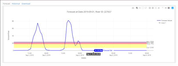
Forecast (54-hour): Forecast information is generated from nine ensemble forecasts and shows the forecasted streamflow for a given period. The different background colours in the graph represent the flow magnitude between defined return periods.
Users can further interact with adjoining tabs to access the following:
Historical: This tab displays a graph of simulated historical flow from 1980 onwards based on ERA5 data.
Download: This tab allows users to download the forecast and historical data as a downloadable CSV file.
